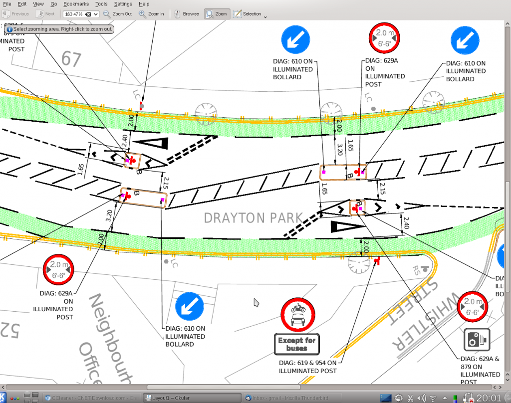
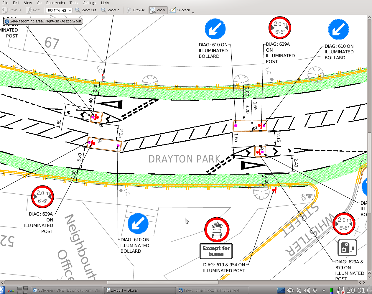
Here’s Islington Council’s proposed second design for the Drayton Park width restriction. The original design wasn’t very popular and was thought to make the road less safe. This time around, Islington Council worked very closely with Sustrans.

The motor vehicles permitted to use the bypass lanes will include:-
(a) anything done with the permission or at the direction of a police constable in uniform;
(b) in respect to a local bus service, a school bus, a coach, a vehicle being used in the service of a local authority for the collection of refuse, demolition or excavation, improvement or reconstruction of the highway, maintenance or building operation; or
(c) any vehicle being used for ambulance, fire brigade or police purposes in an emergency.
(d) those vehicles provided dispensation for access to Network Rail site from the A1 (holloway road).
Others may be provided with special dispensation on request.
I am unable to give accurate numbers for volume of these vehicles however I would estimate it to be normally less than 5 a day. However it should be noted on the occasion Drayton Park is being used as a diversionary route, it is likely all vehicles will be using the bypass lane.
For earlier information about the width restriction
May 7th: Drayton Park – the vanishing cycle bypasses.
[mailchimp-drayton-park]


Far better design, well done. I think its clearer for motorists too.
There needs to be signage at the ends of Drayton Park ‘announcing’ the Lorry Ban – at present, I don’t believe there is.
I also wonder whether the 20MPH signs need to be more prominent as well. The majority of drivers seem to think it’s 30MPH and so feel it’s ok to do 30 to 40 MPH.
This is more like it! Cyclists and pedestrians will now get a much better and safer deal. Get it done quickly and lives will probably be saved, as the present scheme is lethal at worst, frustrating at best. Sort out the echelon parking north of this scheme and I’ll be a happier man.
What an ugly, inelegant solution, a classic example of what happens when you
let UK (motor) traffic engineers loose in a residential area. This
approach is out of date and a fundamental breach of principles for good design of
the public space, such as the officially endorsed Manual for Streets. Honestly, which other
countries in the world would you expect to see something like
this? It’s certainly not ‘Going Dutch’.
Rather than the expense and clutter, why doesn’t the council go back to first principles and use
the tried and tested solution of camera enforcement combined with
detectors in the road that sense large vehicles, something that’s worked on Tower Bridge for nearly a decade?
Please make Drayton Park look like a quality space – not a security checkpoint.
The council officers
report says
3.3 Subsequent to decriminalisation in October 2005, enforcement of the
7.5 tonne lorry ban moved from the Police to local authorities and is currently undertaken by
Parking Services within Public Realm. Enforcement of a lorry ban can be undertaken by either
physical restrictions or CCTV monitoring of vehicle movements. However enforcement solely by CCTV
evidence is impractical in large lorry ban areas.
Bridges strike me as being slightly different, and so might the fines. Are there example of lorry bans on similar roads as Drayton Park?
Spot on R. It is a residential street that needs a simple straight forward solution, not something overengineered. Signage and camera enforcement also works in Hackney. What about pedestrians wanting to cross?
I suggest again: radically slow speeds (not just with signs please), restrict large vechiles with camera enforcement, direct ped crossings from station along desire lines (school and shops I guess). If you paint a cycle lane, please don’t do it as it is now but so it’s actually useful.
Gerhard. Speed, do you mean lower than the existing nominal 20 MPH? Here is the Connect2 ‘short list’ On enforcement, can you be specific about a comparable width restriction in Hackney.
The officers report says
3.3 Subsequent to decriminalisation in October 2005, enforcement of the 7.5 tonne lorry ban moved from the Police to local authorities and is currently undertaken by Parking Services within Public Realm. Enforcement of a lorry ban can be undertaken by either physical restrictions or CCTV monitoring of vehicle movements. However enforcement solely by CCTV evidence is impractical in large lorry ban areas.
Fantastic effort by ICAG to make IBC go back to the drawing board! However, I have to say I am with R on this one. Yes it is better than the other design, but it is just getting more and more cluttered as a design. It does not stop HGVs coming into the area, and as Tescos and Network rail have dispensation, they will now pass the scheme right on top of cyclists. Anyway, it is better, but I think most people have mentioned the speed on the road needs addressing, as well as the terrible parking conditions.
I think this is a much better design than the original. The approaches for motorists are straight forward and it’s easy to make last minute adjustments to get the back wheels in the right place, impossible with the old southbound lane. But it is a very complicated scheme as was the original. However that seems inevitable given the various ways that it’s expected to be used, especially having to take Holloway Road traffic in the event of a major accident etc. (Have asked Paul T for more explanation about how the scheme is expected to operate).
The location might be ideal because it does not disturb residents’ parking bays but I do wonder if it would be easier to put a simpler width restriction further north, beyond the point at point network rail cranes, buses and Holloway Rd diverted traffic would ever be expected to travel, perhaps in Gillespie Road and yes, disturb residents. As Gillespie Rd is not wide enough to support (residents parking on either side and) 2 lanes of traffic, perhaps a single bidirectional width restriction could be installed similar to the ones in Aubert Park. Just a thought.
So where are these hypothetical buses supposed to go now? Next stage in making this area more bikesafe will be to curtain the diagnonal & double parking of vans on the cycle lane outside the café.
I think they go on the left don’t they (going by the signs on the plan)?
I think that is right. They have a 4.8m lane, if you include the cycle lane. They are few and far between.
Peter G F, council officers are working on the echelon parking outside the cafe as part of Connect2.
If there has to be a physical width restriction then this looks like a much better scheme and certainly one that doesn’t make life worse for cyclists in the way the original scheme has. However as R below says, why is a physical scheme needed in the first place? Camera enforcement will still be needed to deter HGVs using the “bus” lane. Why not simply put up width restriction signs and enforce with cameras without the need for such an ugly scheme. Ok it wouldn’t be perfect but wouldn’t it be at least worth trying before going the whole hog as proposed here?
I am not sure the new proposal helps that much. Won’t cyclists get squeezed despite the green cycle lane proposed? Traffic will just spill into it. Am not sure I understand the measurements. Will this really work? The cost of doing this, and then re-doing it must be immense. This is another good reason why planning of cycle routes should be done centrally, by one London wide body, so we have consistency, familiarity, and order for London’s cyclists and road users of all sorts. Again, planners on the mainland laugh at the UK with our hotch-potch amateurism, and inertia in such matters. Mind you ‘planning’ has become a dirty word in the UK, and the poor sods still employed in hard pressed planning departments are poorly supported and largely unloved by the public, often reduced to admin tasks of outsourcing to big private operators, who want to get in and do the job on the cheap. What sort of person drew up these plans? A freelance employed by Balfour Beatty?
I can see no point what-so-ever for the changes made or the the first design either
Waste of rate payes money
The Road was perfect before this change with no black spots what-so -ever in my 70year stay
Still want to know WHAT bus’s run this way???
Why no lorries sign as is why it was put there
Money better spent on housing
Connie, sorry cannot help on the buses, many others have asked the same question and i have asked officers for more operating information.
If you had a twelve year old child, would you allow him or her to cycle along this route? That is one of the objectives of the Connect2 project and that’s why we and Sustrans asked for a redesign.
I think the road was far from perfect. It was a race track with a cycle lane that’s worse than nothing and pinch points designed just to keep cyclists on their toes. So doing something is good. But I doubt this facility will address speeding. Regarding my 12 yo son, I’m happy for him to cycle there. I would be happier if motor traffic was restrained.
OK, spoke too soon, have updated post above. Very roughly 5 wide vehicles including buses a day.
Better, but still not much good. If someone parks in the disabled bay and starts getting out of their car, it will push cyclists into the path of traffic. Pedestrian traffic from the station across Drayton Park is still not well served. But I suppose they couldn’t put a pedestrian crossing there because it’s on a blind corner. In which case, why do they imagine that their width restrictions are in the right place. Lorries are still arriving at the restriction and trying to U-turn. Further, if they knew, as P Taylor says, that “bus” use was 5 a day, why design what they did? Why don’t they stop wasting our money, put it back the way it was, and control the lorries with cameras?
Phil, going to raise the issue of buffer zone between disabled bay and cycle lane with officers.
Islington Council is consulting on the revised design. They are really only looking for show stoppers at this stage. ICAG has already responded favourably.
Much better solution; hope it happens. Pity about the £kkk wasted, simply wasted, on the layout so far.