In early January 2012, ICAG responded to Islington Council’s public consultation on a proposed width restriction on Drayton Park near the railway station. We said ‘we welcome the cycle bypasses on both sides of the restriction’.
Last week, the contractors added the finishing touches to their scheme. However the scheme looked very different to the one that we had been consulted on. That’s not surprising, the contractors were using a different drawing.
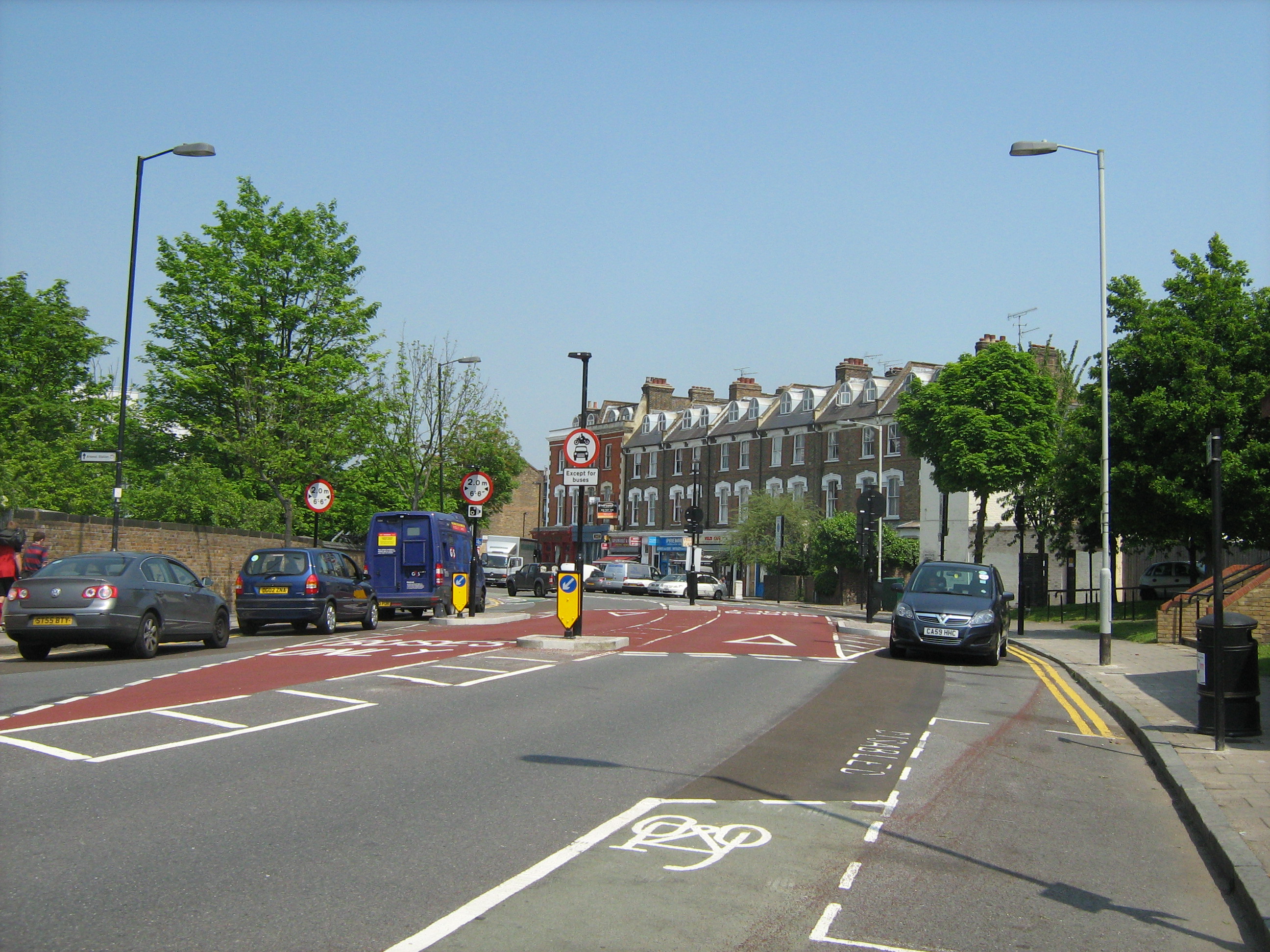
On the original scheme, cyclists are able to bypass the width restrictions and keep well away from the cars. This is considered to be good practice. London Cycling Design Standards says about chicanes and pinch points at 3.6.4 that ‘It is important to ensure that the feature is designed in such a way that cyclists are neither squeezed nor intimidated’.
However on the ground, the cycle bypasses have been removed and cyclists and motorists will be brought into direct conflict as they jostle for position ahead of the restriction. All cyclists will have to take the primary position (centre or right hand side of the lane) well before they reach the width restriction. However some motorists will want to squeeze in front of any cyclists so that the cyclists don’t slow them down. This is what sometimes happens on Benwell Road at a similar width restriction. However Benwell Road traffic flow and speed is much lower than Drayton Park.
Drayton Park forms part of Islington’s second most popular cycle route. The route goes from Finsbury Park to Farringdon via Barnsbury Road.
Islington Council and its partners have received £600,000 funding for a local Sustrans Connect 2 project which links Highbury Fields to Finsbury Park along Drayton Park. The guidelines to the Connect2 project say ”Connect2 will create a new way of living, where people, and not cars, are at the heart of travelling within communities throughout the UK”. The Connect2 project is still in design stage; the width restriction has not been funded by the Connect 2 project.
For most cyclists, this is just a step backwards and a nuisance only 100 yards from another nuisance, a set of echelon parking bays. For potential cyclists, it’s just another reason for their parents to not let them cycle.


May 22nd : Drayton Park The Movie directed by Robin again.
A concern has been that cyclists would have difficulty in establishing primary position in the lane if there is speeding traffic behind them. However this video shows confident cyclists moving into primary position then peeling off to the right, skipping the width restriction and using the wide cycle bypasses now flipped into the center of the road. Cyclists then remerge with the motorised traffic, it’s probably not what motorists expect to happen. The video also shows cyclists queuing in line with vehicles waiting to go through the width restriction.
May 23rd : Drayton Park Squeeze shot from a high quality head camera by cycleoptic (Steve K). But you need an old telephone directory to realign your screen to the horizon.

More Related Stories
May 30th: Islington Gazette: Car accident at controversial new Highbury road safety measure
June 6th: London Cycling Campaign forum – Islington Council create new improved death trap
June 7th: Freedom of Information request to Islington Borough Council
June 21st: ICAG 92% of people surveyed felt Drayton Park less safe
June 22nd: Islington Tribune: Cyclists oppose narrow road layout at Drayton Park
What do we do?
Start again 🙂
Did they knock out the cycle by-passes to avoid losing too much parking? They are determined not to lose parking spaces – sadly this sometimes means compromising safety.
Interesting that both drawings say ‘For information’ towards the bottom of the title block. Neither says ‘For construction’, which you might expect of the one that contractors are building to.
Press release gone out to 2 local papers. Have agreed to meet Peter Gruner (Tribune) at 5PM at location, Caroline R also going to be there. Others welcome.
Also should point out that cameras are going to be fitted to the poles in the middle of the carriageway. So all bike, cars and lorries will have to through the 2 metre gaps at the side of the road. Vehicles going through the middle lanes will get fined! However, motorists might not be happy to be able to drive there one week and not get fined and adapt to the new layout, only to get caught a week later by the cameras.
Has anyone from The Project Centre spoken about the changes? Are they the same team as behind the riversdale road width restriction?
Jono, no we haven’t talked directly to the Project Centre. We have talked to council officers. It will be the council that will initiate any changes. If the Riversdale Rd restriction was introduced recently, it’s very likely that the Project Centre produced the drawings.
Jenni emailed yesterday: I called the council this morning to try to speak to someone about the Drayton Park Width Restrictions that have recently been installed. I was forwarded to a answerphone message, asking me to email this address.
I can only assume that the work is not complete. At present, traffic islands and signs have been installed, but people are driving up to it and are obviously confused as to where they should go, and most are using the lorry lane or swerving late, directly across what was Islington’s second busiest cycle lane, lcn108. The cycle lane has no end – cars are directed across it. As it stands, with no signs warning people of a new road layout, and no end to the cycle lane, I can see a cyclist getting killed here in a matter of days.
Please can someone do something about this ASAP, and can I be conatcted to know who is dealing with this. In particular, a sign telling warning people that the road layout has changed could be installed today.
As it stands, there is nothing forcing car drivers to use the correct lanes or deterring lorry drivers from using Drayton Park, so the width restriction is not deterring anyone and currently is just dangerous – this is why I assume the work is incomplete. I am a local resident, living near Drayton Park. I am not a cyclist, but just really scared for the lives of those that are.
Allen emailed yesterday: Last couple of days have seen improvements to a cyclng lane on Drayton park.
I think they are meant to be helpful to cyclists; there is a car wide cycle lane to the left and a car lane to the right with a give way sign on it – I presume that this is meant to slow cars down to give way to cyslists from the left as they re-enter the main road. Unfortunately the actual effect of the alterations is to confuse motorists – they assume the centre give way lane is a right turn and so duck under and into the cycle lane – which is wide enough for cars. The result is nervy motorists swerving into the cycle lane.
This section of road is now several times more dangerous that it was previously. The cycle lane on the left (both ways) needs to be narrowed so it really is for cyclists only, or the whole mess removed.
I have been cut up twice in two days on this section (I work 50 metres down the road) and fear it’s only a matter of time before someone really gets it.
Drayton Park width restrictions:
I’m unclear about two things:
1) How does the money (£ 600,000) cashed by Islington Council and meant for the cycle route Highbury-Finsbury Park but unspent relate to the work just done on width restrictions?
2) Do(es) the person(s) / committee / assembly who decided to alter the plans think cars will queue up politely behind bicycles in the width-restricted lanes?
Anita Frizzarin
1) They are only related in that Sustrans want to create an exemplary cycle route and this change undermines that effort.
Allen here – a quick update – they have now made the centre lanes red (14 May) and they have coned off the outside lanes for the time being. The cones were up last week and I thought they might have seen sense and be redesigning the work, but painting the middle lands red seems somewhat permanent!
This really is a horrible mistake on such a busy road – it pushes bikes, vans, cars, motorbikes into conflict on a corner just after clearing one of the most dangerous parking bays in the area. It compunds a problem – motorists get frustrated at having to ‘wait’ behind cyclists through this section and then accelerate to clear the cyclists. Now they will accelerate INTO a squeeze point with the inevitable result that cyclists will get cut up.
So in 150 metres you get – busy ‘rat run’ intersection, parallel parkig at shops, truck calming then pedestrian crossing to school. Not a huge problem in itself if everything is well designed, but this isn’t.
Inexperienced cyclists who do not have the courage and confidence to hold a good road position towards this new feature are in real danger I think.
As it stands this scheme is confusing to everyone – I am not surprised that cars are using it incorrectly (and frankly it’s safer that they do!) as there is no signage to communicate what this scheme is meant to do or how to cope with it as a motorist.
Allen, thanks for update. Officers want to meet on site next next week to discuss layout tweaks. But it looks to me as if the best option is to go back to the original design with cycle bypasses and tweak it to accommodate Network Rail’s or any other user’s requirements.
I have cycled along here a few times over the past few days and it is obvious that the work has not yet been completed. No doubt, in due course, it will become much clearer that cars have to squeeze over to the left. But that doesn’t alter the fact that this scheme makes it much more dangerous for cyclists: One day there is a nice bike lane marked out; the next day it has gone and we have to share the reduced space with all other traffic. Please give us the green bike lanes back!
I agree with John that the scheme should be altered so it becomes the one that everyone was consulted on initially & has cycle bypasses included.
I live on Drayton Park, just twenty meters from this Junction. I watched with surprise as they started the works, I thought I will get it soon, but Im still confused. Just like all the cyclists and drivers that approach the junction. I do think it is dangerous as both cars and bikes are squeezed thought the same gap, and no one knows quite why. I mean they have taken probably the widest bit of road in Islington and messed it up. Someone will get injured soon.
One more development, a little sign with a camera has been erected…? I think this could be a bad thing as cars brake quick or swerve to the outside lane to avoid getting caught on camera / fined.
If I can do anything to help, email me pthompson500@gmail.com
I have been to the site today after an LCC member complained about it and I know the area from a few years ago. Can anyone explain what the purpose of all this is please? To me it looked like motors in the middle and cycles on the outside. That wouldn’t be so bad if the parking bays wouldn’t push you into conflict straight after. From the comments below I now gather everyone goes on the outside (width restricted) and the middle is for buses?
It all seems terribly over engineered to me. I think we should look at the original problem and re-think. Can anybody explain the original problem? Thanks
Gerhard, this width restriction is part of a borough wide project to introduce lorry bans on several roads.
If they want to ban lorries (over a certain weight/width I guess) and they have cameras as they do, just use the cameras to pick out the offending lorries.
I suggest:
1. Make wide pavements with inset parking bays if they really have to
2. Leave a 9m (2×4.5m) carriageway with a raised ped crossing along the desire line to the station
3. Reduce speed along all of Drayton Park to 20mph max
3. Maybe square up that turn a little (don’t know enough about frontages etc.)
why not do that?
Hang on. Sorry just noticed. Where is the ped crossing to the train station!? I have often seen people wanting to cross there.
Agree with you on both points Gerhard.
1. Pedestrians leaving the train station don’t have a crossing any more, and just sort of wander across the junction, not know why or how it works.2 Originally I think they intended to calm the speed of the traffic down and make it safer, I can’t remember seeing a accident here, but some cars did take the curve too fast. Unfortunately they have completely over engineered it and achieved the exact opposite, its more dangerous. Putting in a simple zebra crossing may have worked well for everyone. No TFL buses run down Drayton park, and coaches on match day shouldn’t either. The road narrows at arsenal tube station, making it impractical for large vehicles passing through anyway. So dedicating 70% of the centre of the road to them is just… lets just say a little strange. (Maybe it could have been a match day request by the police?just guessing)
Updated pics, showing coloured tarmac finish.
Those are terrific photos. You have a great vantage point. We need to remove that tree so you have got a clear view. Just kidding.
I wrote to james.murray@islington.gov.uk, exec member for transport on Monday on behalf of ICAG. Not heard back yet. Local resident Richard has also emailed him. I have seen a copy of an email sent by a local resident (Highbury West ward) to their local councillors.
Council officers have organised a site meeting for Tuesday 22nd May at 9.30AM. I don’t think that this scheme can be fixed by tweaking it. But if you have any views, thoughts, ideas please come along. Perhaps the meeting would better suit late commuters if it was at 9AM? There is also a Sustrans Connect 2 project meeting on Tuesday evening.
We came through the roadway last night on our tandem. The design is utterly bewildering, and feels like a deliberate attempt at confusing motorists. Depressing to see that when given an opportunity, road engineers make the space more dangerous for vulnerable road users. I come through this road regularly, and don’t mind coming down on Tuesday if it is of help?
Jono
It would be great if you could come. There might be just the 2 of us.
3! I travel with a co-pilot. He is little but quite clear about road provision.
I ride this way fairly regularly (once or twice a week.) Having ridden past/through it a few times now, albeit in it’s current incomplete form, my feeling is that it’s a baffling layout that will have several likely consequences:
1. It will be widely ignored/misused by drivers going straight through the middle
2. It will put cyclists in danger, because drivers who do realise that they’re meant to use the side lanes (and actually do so)
may swerve towards the side of the road suddenly – it is in effect inviting drivers to “left hook” riders every time they use it3. (if it’s enforced e.g. with cameras) it will re-enforce the “war on the motorist” narrative that, aside from being nonsense, causes some drivers to act aggressively towards cyclists and other road users. That is, some will see it as an attempt to catch them out and fine them, rather than whatever the actual purpose is.
The previous layout provided an informal pedestrian perching point (refuge) in the centre of what is a very wide road. This allowed informal crossing to and from the station. The current layout is lethal for people on foot and I just can’t begin to fathom the thinking that suggested it was the right way forward. We need a more people movement friendly arrangement that works for cyclists and for pedestrians. The lorry ban is in response to concerns raised by Cllr de Bono at Highbury West Ward partnership – as far as I remember, there is a problem of large lorries using Gillespie Rd. I don’t have a problem with measures to limit lorry movements on side roads BUT in this case the loss of safety and amenity for cyclists and pedestrians is completely unacceptable.
John, Christine and I will be there for Living Streets tomorrow.
It beggars belief that traffic planners did not consult cyclist before wasting money on this and it beggars belief the planners could produce a plan that does nothing but cater for motorised traffic. It is a death trap for the unsuspecting cyclist and for pedestrians..
David Trillo
As I rode over it this morning they had painted the white ‘Bus Lane’ markings on and reopened the side lanes, forcing all the traffic together again. And it’s still lethal, but at least it’s clear(er) to motorists that they shouldn’t be using the middle lanes. The more you look at it the worse it gets!!
Allen, thanks for the update. Glad it’s now operating the way the designers expected it to do especially as the site visit is tomorrow morning.
We met with council officers, Paul Taylor and Michael Fletcher this morning on site. There was a frank exchange of views. Living Streets was present as well. A passing cyclist contributed ‘What idiot designed this scheme?’.
Paul Taylor restated the council’s legal duty to keep Drayton Park available as an emergency route between Holloway Rd and Finsbury Park. In the event of a serious accident on Holloway Road, the wide lanes are needed to carry all the diverted traffic in the the middle of the road. ICAG isn’t/wasn’t able to counter that argument. Mike Fletcher argued that this was the same kind of width restriction found elsewhere in the borough. We agreed to strongly disagree. Paul Taylor also said that Sustrans would have preferred the original design.
Cllr James Murray’s office emailed to say that James Murray couldn’t make this morning’s meeting but have agreed to have a site meeting in the next couple of weeks.
Hi John,
I have put a new video up showing the new road layout here http://www.youtube.com/watch?v=_XoOE781PDA I am just getting some opinions on what people make of the design. If the council are planning more of these designs, I think it would be good to record some feedback from users on this scheme first.
Dear Caroline [Living Streets] & John
Further to the recent correspondence concerning the new width restriction in Drayton Park and our meeting on site this morning, please see my comments below.
The new width restriction in Drayton Park is now complete. The temporary traffic management (cones & signs) have now been removed and the restriction will begin operating as intended. However please note that enforcement will not be immediate and there will be a period of grace to allow drivers to become accustomed to the new road layout.
Scheme Expectation:-
We expect the scheme to have a significant impact, preventing Heavy Goods Vehicles using the Highbury area as a through route between Blackstock Road and Holloway Road. The central gap will allow permitted vehicles access and is enforced by a permanent CCTV facility. Furthermore the two lanes in the central gap allow us to safely use Drayton Park as an emergency diversion route for all vehicles including HGVs, if Holloway Road or Blackstock Road are closed for any reason.
Pedestrian Impact:
The construction of the width restriction required the removal of an existing pedestrian refuge which provided an uncontrolled crossing point between Whistler Street and Drayton Park station. Our site observations indicated that this was infrequently used and that there is a nearby zebra crossing at the junction with Arvon Road. The width restriction will provide a traffic calming effect at this location with vehicles slowing significantly to negotiate the narrow traffic lane and I would suggest that some pedestrians who wish to cross may take advantage of this though it is not specifically designed as a pedestrian crossing. For those who do not and still wish to access Whistler Street, the Arvon Road zebra crossing is less than 50m away.
Cycles Impact:-
The initial design used for the consultation indicated 3 traffic islands with 4 lanes. The two central lanes provided the 6’6” lanes for normal through traffic with two wider bypass lanes adjacent to the kerb for use by emergency services, waste refuse vehicles. It was assumed cycles would utilise the wider bypass lanes as they are infrequently used and would allow them to continue along their desire line, adjacent to the kerb.
As a result of the consultation it became clear that the bypass lanes were not wide enough to allow all HGVs which may need to access the area or use the route during an emergency diversion. Therefore during the detailed design stage the lanes layout was amended. It was noted that this would perhaps be less preferable for cyclists however we do not feel the current layout is unsafe for cyclists for a number of reasons.
A) Vehicles slow considerably to negotiate the 6’6” gap allowing cyclists to mix with traffic.
B) a pinch point for cyclists is regarded as a gap where cycles and vehicles could pass through side by side but with minimal tolerance. This is not the case at this type of gap.
C) The requirement for cycles to mix with traffic is no different from any of the other width restrictions in the borough, some of which occur on busy cycle network routes such as Colebrooke Row and Thornhill Road, where they operate safely.
Scrap Metal Dealers by width restriction:-
A length of single yellow line has been maintained outside the premises of the scrap metal dealers to allow them to load and unload. While works to construct the restriction have been undertaken it would appear that goods vehicle drivers have taken advantage of the temporary traffic management outside the site, parking adjacent to the signs & cones. This will be prevented by appropriate parking enforcement when the restriction begins operation, to prevent an obstruction being caused.
Further action:-
The restriction will be subject to post construction (stage 3) safety audit which we intend to undertake in late July, prior to the end of the school summer term. This will feed in to discussion with councillors and stakeholders about the operation of the restriction where we can review the scheme and provide any conclusions in a 6-month post implementation review report, which will include any remedial measures if required.
Regards
Paul Taylor
Transportation Manager
Traffic and Engineering
Environment and Regeneration
Islington Council
222 Upper Street, Islington, London, N1 1XR
“… for use by emergency services, waste refuse vehicles. It was assumed cycles would utilise the wider bypass lanes as they are infrequently used and would allow them to continue along their desire line, adjacent to the kerb.”
The sign specifically prohibits motor vehicles “except buses”, since when has a waste refuse (18 Ton+ HGV vehicle) been a bus?
Hello, never posted here before but I’m a regular user of this road. Here’s the letter I sent to James Murray and the reply I got from Theresa Delbono (one of the ward councillors) to whom I copied it.
Dear Sir,I am a resident of Finsbury Park and cycle to work in central London passing along Drayton Park twice a day.I am writing to let you, as executive member for transport on Islington Council, know what my experience has been of the new traffic scheme which has been recently implemented near Drayton Park station and to ask you some questions about it.As you may know, the new scheme has split each carriageway into two lanes with all vehicles except buses required to go to the left of an island through a narrow gap. Buses can go straight ahead on the right (giving way to traffic on the left where the two lanes merge again). The cycle lane along Drayton Park appears to have been discontinued at the entrance to the scheme although it is not clear from markings whether the intention is to reroute this onto the pavement until it reappears on the road on the other side.At the moment, at any rate, cyclists are presumably expected to continue to ride on the left hand side of the road through the narrow gap for non-bus vehicles.The consequence of this in my experience is that car drivers, eager not to get held up by cyclists going through the restriction, attempt to accelerate past them before reaching it. So far in only a week I have been “cut up” twice in this way, as cars have narrowly missed me having attempted to overtake dangerously. As a consequence I have started to pull out to ride through the central bus lane, but this is not something I am particularly happy about doing either as it means crossing the flow of car traffic twice. Even if the next stage of the scheme is to route the cycle lane up onto the pavement I would not regard this as a particularly attractive option as it would risk conflict with pedestrians while on the pavement (who would not be expecting the cycle path over such a short distance), and with motor traffic when merging back onto the road.Overall, therefore my experience of this new scheme is that it has made this section of Drayton Park significantly more hazardous for me as a cyclist to negotiate.Given this I should be very grateful for your clarification of the following points:- What is the purpose of this scheme? And what is the point of the way in which buses are treated when there is no regular public transport bus service on this road?- What consultation was there on the scheme and what attempt in particular was made to seek the views of regular users, especially cyclists? I was certainly unaware of it until I saw the works start;- What assessment of the impact on cyclist safety was made and by whom? Who signed off any relevant risk/safety assessment for cyclists?- What monitoring of the scheme now in place is planned to see whether it achieves its intended purpose or has any unintended negative consequences?- What options, including removal of the scheme, would be considered following any such monitoring?I have sought in writing the above to adopt a balanced and reasonable attitude. However, my feelings are ones of surprise, incomprehension, anger and dismay that such an apparently thoughtless and poorly communicated road management measure has been implemented without obvious consideration of the impact it will have on vulnerable users of this road and consequentially on the general willingness of people to adopt cycling in London as a sustainable alternative to motor transport.I look forward to your reply,Yours sincerely,Graham Turnock
***************
Dear Mr Turnock Thank you for copying me on the email to Cllr Murray. Please note that this scheme is not finalised as yet and the Council officers are working with Sustran to perfect it. RegardsTheresa DebonoCllr for Highbury West
Graham, that’s a very helpful post, thanks. Sustrans will be relieved to hear that the scheme just needs perfecting. (Will sort out post formatting tomorrow).
I visited a friend in Drayton Park a couple of days ago, and so had the chance to see the new scheme first-hand. I used the kerbside lane in one direction, and the ‘bus-only’ central by-pass on the way back, and didn’t find any particular problem with either. Other people’s mileage may vary.
For me, the worst feature of Drayton Park is the cycle lanes. They fill with grit, because they don’t get automatically swept by car tyres, and they encourage people to cycle too far to the left, often in the dooring zone. They should be removed, as should the similar dooring ‘facilities’ on Market Road.
Trevor, fixing the cycle lanes is on the list of things that should get fixed as part of Connect 2. I am not sure whether that means taking them out or repositioning them, that detail hasn’t been discussed but the work is in the budget. It will be interesting to hear Sustrans’s view on that.
We met with Cllr James Murray, local councillors and officers this morning on site.
Cllr Murray did not want to start again on the design. Council officers restated the need to use Drayton Park to carry emergency and wide vehicles, including now apparently cranes and Cllr Murray was keen for us to accept this as fact.
A lot of cyclists are using the central lanes as cycle bypasses to overtake the cars queuing at the width restrictions. Extending that pattern, Cllr Richard Greening suggested that cyclists should use the center of the road for a much longer length of Drayton Park. Although aware that the anti segregationists would not be happy with this on principle, I welcomed this suggestion because Drayton Park is very wide and Sustrans might also find this attractive as a key feature of their Connect2 route. I think we (at the meeting) were aware that this creates quite an engineering challenge, particularly at the start and end where cyclists pass into and out of the central cycle lanes. Any comments? Anyway council officers are going to look at this (see notes below).
Other interesting things that came up. The location of this width restriction was strongly influenced by the desire to not disturb residents car parking elsewhere on the route. Also it might be possible to use the original layout (top drawing) with removal street furniture although Z was very doubtful that was practical because removable street furniture is much more easily damaged by vehicles.
Here are the official notes:
Attendees
Cllr J Murray
Cllr R Greening
Cllr T Debono
Zahur Khan – LBI
Paul Taylor – LBI
Simon Court- LBI
Sue Powell – LBI
Caroline Russell – Living Streets
John Ackers- ICAG
Thanks for the positive meeting this morning. Please see below the resolutions on which we agreed.
To address the concerns raised by Sue & Simon of the Islington Learning Difficulties Partnership regarding disabled parking we will look to provide a disabled parking bay in Whistler Street. (location to be agreed with Sue & Simon).
To help address the cycling concerns we will investigate the possibility of a centrally located cycle lane in Drayton Park. Also we look in to the alignment of approach vehicles as they come toward the restriction.
To address the concerns of Living Streets we shall look to provide an informal crossing outside the station to the east of Arvon Road.
In terms of time scales we will commence design of the disabled bay immediately with a view to contact Sue & Simon to discuss the proposed location toward the end of next week. With regard to the cycle lane this may take longer but can be part of an ongoing review with which we will work closely with ICAG as agreed.
The informal pedestrian crossing is at present a proposal as part of the Connect2 scheme, which we will look to take forward this financial year in co-ordination with Bryn Lockwood of Sustrans. We will also inform Sustrans of the disabled bay proposal and possible cycle lane amendments and the review of the width restriction.
As noted in previous correspondence the restriction will be subject to post construction (stage 3) safety audit which we intend to undertake in July, prior to the end of the school summer term. This will feed in to discussion with councillors and stakeholders about the operation of the restriction where we can review the scheme and provide any conclusions
in a 6-month post implementation review report, which will include any remedial measures if required. I will provide you with a firmer programme of review next week.
Regards
Paul Taylor
Transportation Manager
Traffic and Engineering
Environment and Regeneration
Islington Council
Hello everyone, I live on Drayton Park and I am a cyclist, and am a bit confused and annoyed by this change. I emailed Cllr Debono, and got a fairly poor response which showed she clearly did not know the area I was referring to.
“Deasr Will, There was a lengthy consulttion on this scheme and the reason it is put there is because of the amount of HGVs that are thundering down our roads. The scheme is not finalized as yet, and we are looking at ways to make it easier to cyclists to go through. Sustran is working with the council on this and hopefully, they will come up with something to make residents and cyclists going through happy and safe. RegardsTheresa Debono”I found this website through google, and I’m delighted to see that you’ve had some success and met the Council today. I’ll keep my eye on this site now!
Best,
Will
Well done John for getting the meeting sorted, hope you didn’t feel outnumbered by LBI. As a reference, is the entire scheme now complete? I had a look at the other restrictions Paul mentioned last week (Thornhill and Riversdale) Although have similar elements, it really is not the case that they are the same design. Speed of approach and lane change are really important factors to consider. In addition many cyclists feel those 2 designs are very poor, so continuing to copy them is not best practice. Feel free to email me jonokenyo@gmail.com
Regards
Yes, the scheme is complete. Completely agree that the same engineering approach cannot be used for all width restrictions. The London Cycling Design Standards says at para 3.2.11 about ‘Restrictions on HGVs’ that ‘cycle bypasses to width restrictions may be appropriate and these should provide a minimum of 1.5m clear width for cyclists’.
Hi everyone, well I have just seen my first crash, and have attached a photo. A young man in a car (might have been angry about an incident 20 meters before) tried to go though the gap too fast, hit the curb and the car flipped onto its side, They then flipped the car back but as you can see the iron bollard is under the car (by the right wheel) The point is, its lucky no one was hurt, lets hope next time no one is hurt either.
Nice pic. That’ll learn him. A strong contender for Moving Target’s ‘muppet of the month’ award.
If you look at my video you can see that this type of car can hardly get through at a very slow crawl.
One more off the road 🙂
cycleoptic
Paul, the pic is good but can you get one with less street furniture that the papers could use?
Great. I’ve been cycling this route for five years and I’m horrified, we’ll be fighting for space and wholly dependent on drivers’ courtesy and judgement. Only a matter of time before a cyclist comes off. Fingers crossed.
I’ve just come back from Drayton Park. The car was on a low loader about to be removed (10.15pm). I have the details for the driver. Apparently he came in at a bit of an angle travelling towards Holloway Rd, hit the right hand kerb of restriction, bounced on to the bollard and the car flipped on its side, with the left hand bollard crunching through rear passenger window. Luckily no rear passenger. He pushed the car upright v quickly, the police attended “but were not v interested”. Locals had to direct traffic through central “bus” lane for about an hour.
Lots of cars approach at an angle when they divert from centre of the road. Not sure the “innovative” design took that into consideration.
Always hate cycling past the echelon parking but this just extends the adrenalin run. It doesn’t work for people in cars, on bikes or on foot – #fail
I saw the aftermath of it at around 6:45pm, as Paul Thompson below describes. I would have taken a photo, but there were a lot of people who both angry and shaken, so I moved along. Oddly, some drivers were queuing up behind the stricken car, seemingly unsure whether they were allowed to use the ‘bus lane’! In any case, cars, and of course me on my bike, used the bus lane
hello, i live in Highbury as well and though i don’t use this part of the road for cycling, nor for crossing the road I think it’s the most stupid piece of road layout I think I have ever seen! bus lanes for no buses; no cycle lanes for cyclists and nowhere for pedestrians to cross (and I imagine when it finally does rain the water will be sitting on the pavement still and forcing people to walk into the road or get wet feet in the puddles, but hey, I could be wrong! I want to thank you for taking this up and putting pressure on the local council to relook at this. The only good thing is that I no longer have the odd HGV driving past my flat but I would trade this in if it meant a life being preserved on our streets.
I also saw the car accident today and have a picture on my phone if it of use to anyone?
L, yes it would be good to see the photo. (You can add an image to a comment, as Paul has done below. Disqus stores the photo in different sizes). Thanks John
L Evans – Please post your picture of the car on its side. The Islington Gazette are after one.
Hi, Tom from Islington Gazette here. If you could send it to tom.marshall@archant.co.uk that would be great
Agrre with all you say
A BUS LANE buses dont run down Drayton Park
Has IBC GONE MAD
aLREADY THERE HAS BEEN AN ACCIDENT THERE
TOO much money to waste
I forgot to say I use Drayton Park station for commuting to and from work.
Hi, afraid it’s not the best photo, like Will below I didn’t want to be too much of a voyeur here! it was taken just after 7 pm and although there wasn’t any police car on the scene at this point there was a lady on the far right of the picture who may possibly have been a very casually dressed one! she was on the phone.
hope it is of some use somewhere.
i’ll try photo again!
umm.. it seems to not be uploading..! do i have to register to do this?
I don’t think so.
Hi, Tom from Islington Gazette here. If you could send it to tom.marshall@archant.co.uk that would be great
have just sent it to you so I hope you receive it.
Could you send me a copy as well. I have sent you an e-mail. I will post it on the website many thanks.
What a stupid concept Stupid it don’t make sense and made cycling even more dangerous
Oh my goodness drive this everyday it is a terrible idea
What a terrible idea! Drive it everyday and it is an accident waiting to happen!!!!
Hello again, I posted the letter I sent to Councillor Murray a couple of weeks back. I’ve now had the following reply:
Dear Mr Turnock
I write with regard to your email to Cllr Murray as below. With regard to your specific questions I would respond as follows.
– What is the purpose of this scheme? And what is the point of the way in which buses are treated when there is no regular public transport bus service on this road?
We expect the scheme to prevent Heavy Goods Vehicles using the Highbury area as a through route between Blackstock Road and Holloway Road. The central gap will allow permitted vehicles access and is enforced by a permanent CCTV facility. Furthermore the two lanes in the central gap allow us to safely use Drayton Park as an emergency diversion route for all vehicles including HGVs, if Holloway Road or Blackstock Road are closed for any reason. It has been marked as a bus lane to provide a clear deterant to drivers that they should not be using the central lane and who may consider using an unmarked central lane.
– What consultation was there on the scheme and what attempt in particular was made to seek the views of regular users, especially cyclists? I was certainly unaware of it until I saw the works start;
Consultation was undertaken on line and notification of the consultation was delivered to all residents and businesses in the area as shown bounded in green in the attached. Of the respondents 79% were in favour of the proposed scheme.
ICAG (Islington Cycle Action Group) were also consulted with regard to the scheme. The initial design used for the consultation indicated 3 traffic islands with 4 lanes. The two central lanes provided the 6’6″ lanes for normal through traffic with two wider bypass lanes adjacent to the kerb for use by emergency services, waste refuse vehicles. It was assumed cycles would utilise the wider bypass lanes as they are infrequently used and would allow them to continue along their desire line, adjacent to the kerb.
As a result of the consultation it became clear that the bypass lanes were not wide enough to allow all HGVs which may need to access the area or use the route during an emergency diversion. Therefore during the detailed design stage the lanes layout was amended. It was noted that this would perhaps be less preferable for cyclists however we do not feel the current layout is unsafe for cyclists for a number of reasons.
A) Vehicles slow considerably to negotiate the 6’6″ gap allowing cyclists to mix with traffic.B) a pinch point for cyclists is regarded as a gap where cycles and vehicles could pass through side by side but with minimal tolerance. This is not the case at this type of gap.C) The requirement for cycles to mix with traffic is no different from any of the other width restrictions in the borough, some of which occur on busy cycle network routes such as Colebrooke Row and Thornhill Road, where they operate safely.
– What assessment of the impact on cyclist safety was made and by whom? Who signed off any relevant risk/safety assessment for cyclists?
Please see above plus safety audit was undertaken as part of the design process and recommendations are prepared by officers in a report. The report is then signed off by the Director of Public Realm.
– What monitoring of the scheme now in place is planned to see whether it achieves its intended purpose or has any unintended negative consequences?
We have already had a site meeting with Cllr Murray, Ward Councillors and representatives of ICAG & Living Streets at which initial recommendations for consideration have been proposed as part of the review process. The restriction will be subject to post construction (stage 3) safety audit which we intend to undertake in late July, prior to the end of the school summer term. This will feed in to further discussion with councillors and stakeholders about the operation of the restriction where we can review the scheme and provide any conclusions in a 6-month post implementation review report, which will include any remedial measures if required.
– What options, including removal of the scheme, would be considered following any such monitoring?
All options can be considered and reviewed during the monitoring process.
Regards
Paul TaylorTransportation ManagerTraffic and EngineeringEnvironment and RegenerationIslington Council222 Upper Street, Islington, London, N1 1XR
Tel: 020 7527 8038Mobile: 07825 098874
Alternative Contact: Mike Fletcher 020 7527 2610
One practical thought has struck me re the scheme and a possible redesign. Why does the central bus/emergency HGV section have to be two way. Given how infrequently it is likely to be used could it not simply be a single lane with priority in one direction. This would free up a significant amount of space (taking into account the central island) which could then allow the car lanes to move inwards and cycle lanes to continue on the kerb line.
As for the central cycle lane I’m personally not keen on this at all given the need to switch in and out and the risk from cyclists coming in the opposite direction.
Finally, are ICAG giving Islington a hard time over the consultation? To change the plan so radically and not go back to consult at least representative groups strikes me as quite deficient. Also the lack of an attempt to engage with road users in the first instance (cf by contrast the consultation over the Finsbury Park station junction recently) looks negligent – whether wilfully or not I don’t know but one can speculate.
(And another thing) why do we need this scheme in the first place if HGVs are still perfectly free to use the road with nothing other than CCTV policing? Surely signs could have simply been put up banning HGVs and CCTV installed on the road as it was or is this clearly dangerous and no doubt expensive scheme little more than a very elaborate means of communication?
Graham
Thanks for posting up your emails.
I get the impression that the bus/emergency section need not be 2 way. Looking at the drawing above, it might be possible to squeeze in 2+2+1 lanes but there would be 4 islands which would really be pretty awful for pedestrians (although possibly better than existing arrangement of staggered pedestrian refuges) – worth raising with Paul Taylor.
I was wondering if the middle island in the original design (above) could be made low enough so that wide emergency vehicles could occasionally pass over it and occupy both lanes. But that might not allow the route to be used as an alternative to Holloway Rd in the event of an emergency.
Sustran’s Connect2 engineer is visiting the site this week, it will be interesting to hear his views.
I raised the lack of consultation on the second design with Cllr James Murray by email and at the last site meeting so he can prevent this happening again!
Your comparison with Finsbury Park station junction is interesting, that’s part of the Connect2 scheme.
John
Yes, good point re pedestrians but are pedestrians likely to want to cross anywhere near this in the first place? Interesting to see what the sustrans engineer says as you say.
Just reading through the older comments, I think that the most popular vote would be for removal of the whole scheme and to redesign the road markings to provide standard (4.5m?) lanes of consistent width that reduce the speed of the traffic (picking up Gerhard’s point).
If, because of lack of space, there are no cycle bypasses, there should be no width restriction for HGVs. HGV ban and enforcement should be done via cameras or other technology that is effective and that the police are happy to operate this. If it cannot be implemented so be it. Jono Kenyon has made the point (not below) that he’d rather cycle with HGVs on the road than have to cycle through that width restriction.
John,
I am back from Copenhagen (wow we can but dream of a future!) Further to the points raised below by Paul @ IC, I think it is worth highlighting 2 things. Firstly this scheme does not stop HGVs from driving through the area. As Paul admited, Network Rail, Tescos and anyone else making deliveries, will still be legitimately able to drive through the restriction. Secondly, there are no width restriction signs on Blackstock Road. The first sign is on Drayton Park itself. If this scheme is meant to stop HGV movements it would have been put at the start of the route. It needs a complete overhaul.
Jono, thanks for great feedback. I will feedback this and other things mentioned by others in the next few days. I wonder whether they actually know how many HGVs were using the route before and how many are using the route now?
I think it’s generally accepted that this is a silly and dangerous piece of traffic engineering and bears little relation to the plans which went out for public consultation. The question I want answered is: who was allowed to use their imagination to re-interpret the plan, and why?
The cycle paths in Drayton Park have been useless for a long time now, there are cars parked to the left so a door can swing open in front of you so to avoid this risk you have to move out of the cycle path and take a more centre of the road position, so cars behind you get frustrated as your not in the cycle lane, often parts of the cycle path have transit vans blocking it and before you get to the station towards Holloway direction after the group of shops there is front and back ends of vehicles taking up the whole width of the cycle lane. Now this concept of a useless bus lane in the middle of the road and merging cars on what was the cycle lane is idiocy the people that done this surely need mental health need treatment ?
Mark, thanks for your comments. Sustrans are going to fix the cycle lanes as part of the Connect 2 project. Do you think that the cycle lanes should be removed entirely? Or should the cycle lanes be relocated outside the dooring zone. Local residents have written to local councillors about vehicles parked outside the station and ICAG has written to local councillors about the appalling echelon parking by the shops but nothing has happened so far.
I live off Drayton Pk, cycle this route regularly and am as baffled as everyone else as to the efficacy of this design. In ten years I can’t think when a bus was diverted down this street, therefore – as a previous poster noted – two lanes for buses seems absurd (Theberton Street has one central lane for buses/emergency vehicles). Moreover, other than when the old Highbury Library was being redeveloped I’ve rarely seen hgv’s use the road.
The already poor cycle lanes are ended and restarted to suggest we should cycle on the pavement, and although there is a pedestrian crossing by Martineau Road the loss of the traffic island to accommodate this new layout is regrettable. I’ve never thought Islington’s road planning to be overly cycle friendly in the past but this scheme is a mess.
As part of national bike week, ICAG will be running a stall on June 20th almost next to the south bound width restriction between 8AM and 9.30AM. We’re going to be collecting signatures for a petition about the width restriction. We hope that people will drop by to talk about this width restriction and sign the petition.
We’ll also be discussing what can be done about the width restriction and the wording of the petition at the next ICAG monthly meeting on June 13th, 7.30PM at Islington Town Hall. All welcome.
Re: Drayton Park. As a recent convert to the study of counterfactuals, I’m fascinated by the provision of bus lanes for non-existing buses, and the removal of bicycle lanes for existing bicycles. Aristotle, Theophrastos and Philos Megaricos couldn’t have thought of that!
There are rumours that council officers have whipped a new design.
Hello There everyone i am one of the business on Drayton Park Premier Plumbing and find this width restriction a pointless waste of money it has now made it even more dangerous for cyclists. Lorry’s now delivering to the five business on drayton park martineau road corner now have to make extended journey’s through residential area’s like highbury hill and aubert park they also have to make three point turns in the road to exit after making deliveries to our business surely that cant be progress for londons transport system!! lorrys should be made to keep to main roads as much as possible we have for many years been in contact with islington council parking to try and resolve the parking issues outside our business with out any success when islington council over many years have removed many parking bays for customers sometimes there is no alternative than to double park while loading this makes it extreamly dangerous for cyclist and customers we have now lost all of the single yellow lines opposite the shops used for customers to park and load due to the width restriction. the parking bays in front of the shops are most of the time full with residents parking thus making it impossible for our customers to park and shop and load safely resulting in double parking, the parking bays should be for business parking only there is plenty of residents parking up on martineau road or whistler street this would result in less double parking the council could make the bays out side the shops deeper there is plenty of room to add 3 foot of depth to parking bays thus relieving the overhang onto the cyclist path
Glenn, Thanks for your informative post. I don’t think ICAG was aware that you had been in contact with the council about the (echelon) parking issues. I think you are raising some interesting issues that aren’t necessarily going to be resolved with the newer design. Completely agree that it would be possible to redesign the road layout to accomodate deeper parking bays and ICAG is hoping and expecting this will be fixed/resolved as part of the Connect2 scheme (links above).
I had a quick chat with ICAG this morning near the bypasses, expressing my disgust at this attempt to use cyclists as mobile speed reduction features for vehicles rather than providing proper space for bikes. At the very least the cycle lane should extend through the restriction indicating the correct primary position, rather than bending towards the kerb before disappearing, suggesting that cyclists should take a passive position on the road.
Interested to read the response below from Paul Taylor. He appears to live in some sort of fantasy land where everyone plays fair and vehicles wait patiently behind slower moving cycles. Requiring cycles to ‘mix with traffic’ at this location usually involves sprinting up to a similar speed as vehicles while moving out into the road to the right of the marked cycle lane, blocking the road to prevent a dangerous attempt to overtake immediately before the width restriction. I can do this but would one of the children at the nearby school be able to ‘mix with traffic’ in this way? Perhaps in Paul Taylor’s fantasy world they can.
I expect lots of children at the nearby school would like to cycle to school unaccompanied if they were provided with a safe environment in which to do so. Consequently I’m sure Paul Taylor would be pleased to prove his commitment to this design by turning up at rush hour and instructing some primary age children on how to ‘mix with traffic’.
Here is the long awaited new design.